
Thu Dec 04 11:40:00 UTC 2025: Here’s a news article summarizing the text:
Arctic Blast Grips Midwest and Northeast, I-95 Corridor Braces for Light Snow and Bitter Cold
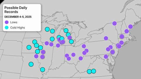
A wave of frigid Arctic air is plunging temperatures across the Midwest and Northeast, threatening daily record lows from South Dakota to New York City. Aberdeen, South Dakota, already tied its record low of minus 18 degrees on Wednesday, and Thursday saw temperatures plummeting below zero in Iowa, Minnesota, and Wisconsin.
The National Weather Service warns that cities like Chicago, Pittsburgh, and even New York City’s airports could see record-breaking cold temperatures through Friday. Record cold daily highs are also possible, particularly in the Midwest, with cities like Detroit, Milwaukee, and Roanoke, Virginia potentially experiencing unusually frigid daytime temperatures.
While the cold front is expected to be relatively dry, areas along the I-95 corridor could see light snow, possibly in the form of quick, intense snow squalls that could create sudden whiteout conditions. Parts of the Appalachians, North Carolina, and Virginia may also experience brief periods of snow or sleet.
A second, albeit less intense, surge of cold air will arrive in the Northern Plains and upper Midwest on Saturday. This will reinforce the already frigid temperatures.
The cold will then push south and eastward, reaching the I-95 corridor by Monday. Cities from Philadelphia to Boston are expected to see a significant drop in temperatures, with highs struggling to rise above freezing on Monday and Tuesday. The I-95 corridor could see lows plunge into the teens Tuesday morning.
While the news is grim for those enduring the cold, relief is on the horizon. A warming trend is expected to begin early next week, with temperatures potentially reaching the 50s as far north as Montana.
