
Sat Jan 24 11:00:00 UTC 2026: ### Headline: Arctic Blast and Winter Storm to Cripple Louisville, Kentucky
The Story:
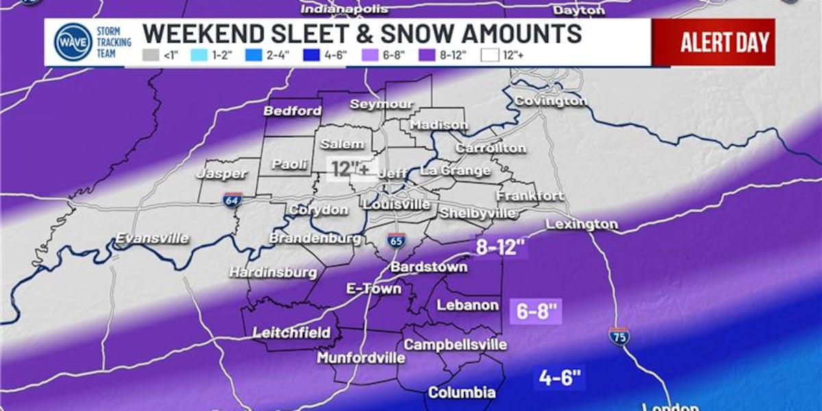
Louisville, Kentucky is bracing for a severe winter storm following an arctic blast set to plummet temperatures into the single digits. A WAVE news report issued on January 25, 2025, warns of heavy snow beginning midday Saturday, intensifying through the afternoon and evening, making travel increasingly difficult. Accumulations of 4 to 6 inches are expected Saturday night, with some areas south of the Kentucky Parkways potentially experiencing sleet or freezing rain. Conditions are expected to worsen Sunday with an additional 6-12 inches of snowfall anticipated, and sleet/ice spreading further north.
The report emphasizes that the winter storm’s impact will extend for several days, compounded by dangerously cold weather. There is also a possibility of light snow again on Wednesday night. Residents are urged to stay safe and monitor forecast changes closely.
Key Points:
- An arctic blast is expected to bring single-digit temperatures to Louisville.
- Heavy snow is predicted to begin Saturday midday and continue through Sunday.
- Snow accumulations of 4-6 inches Saturday night and an additional 6-12 inches Sunday are expected.
- Areas south of the Kentucky Parkways may experience sleet or freezing rain.
- Dangerously cold weather will persist for several days after the storm.
- A chance of light snow is forecast for Wednesday night.
Key Takeaways:
- Louisville is facing a significant weather event that will disrupt daily life.
- Travel is expected to be hazardous due to heavy snow and potential ice.
- Residents need to prepare for prolonged periods of extremely cold weather.
- The forecast emphasizes the need for constant monitoring and adaptation due to the evolving nature of the storm.
- The southern regions near Kentucky Parkways face the possibility of ice accumulation, posing an additional hazard.
