
Sun Nov 03 11:50:00 UTC 2024: ## Recent Surge in Category 5 Hurricanes Raises Concerns
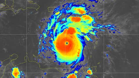
The recent intensification of Hurricane Kristy to a Category 5 in the Eastern Pacific Ocean, despite its distance from land, has highlighted the growing trend of powerful hurricanes in recent years. This marks the sixth Category 5 hurricane in the Eastern Pacific and Atlantic basins over the past two hurricane seasons, a significant increase compared to historical averages.
While Kristy’s Category 5 status was short-lived, it underscores the potential for catastrophic damage that these storms can cause. Category 5 hurricanes, with sustained winds of 157 mph or higher, can inflict severe wind damage, flooding, and storm surge.
This year alone, Hurricane Milton also reached Category 5 twice in the Gulf of Mexico, and Hurricane Beryl became the earliest Atlantic Basin Category 5 on record in July. Last year, three Category 5 hurricanes formed, including Otis, which made a devastating landfall in Acapulco, Mexico.
Historically, the Atlantic basin sees an average of one Category 5 hurricane every 2 to 3 years, and the Eastern Pacific sees one every 3 to 4 years. However, recent years have seen an increase in activity, with 10 Category 5 hurricanes in the Atlantic from 2016 to 2024, and 8 in the Eastern Pacific from 2003 to 2007.
The reasons behind this surge in Category 5 hurricanes are complex and subject to ongoing research. However, climate change is increasingly recognized as a contributing factor, potentially leading to warmer ocean temperatures that fuel hurricane intensification.
While most Category 5 hurricanes remain far from land, the threat they pose cannot be ignored. The potential for devastating landfalls, as seen with Otis, remains a major concern, and continued monitoring and preparedness are crucial for mitigating the impact of these powerful storms.
